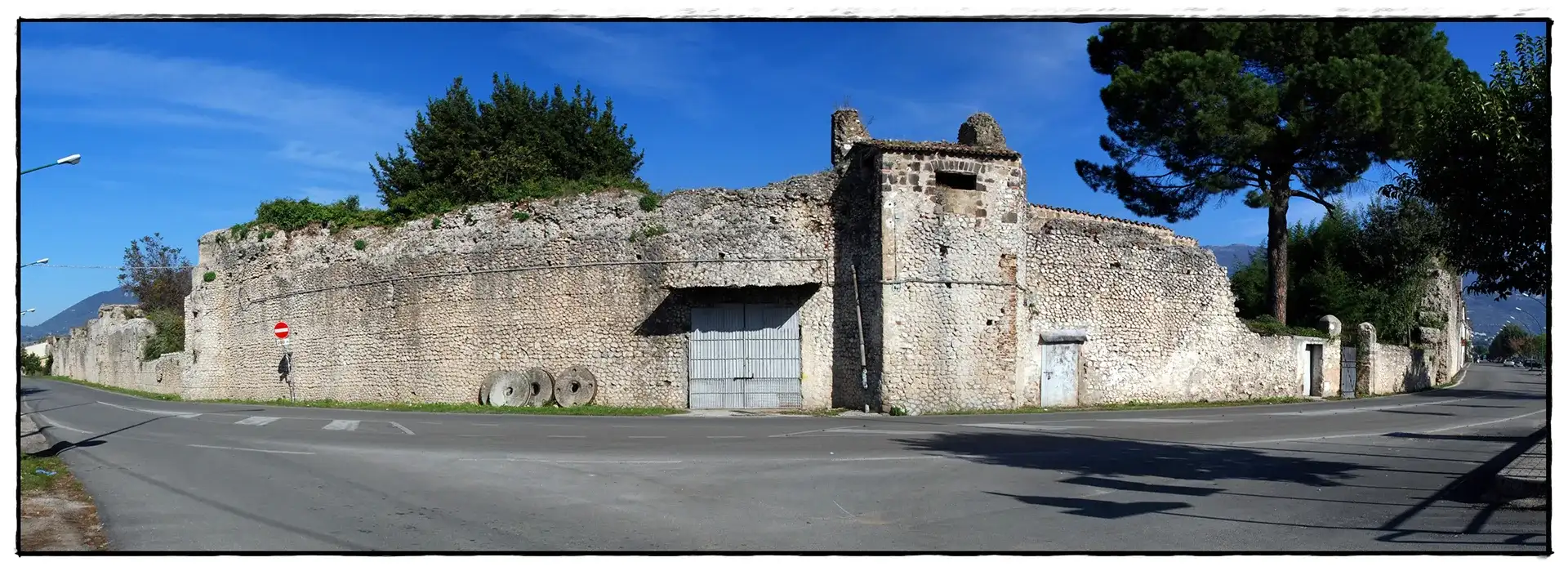
Le Mura Romane di Alife — 1,9 km di Cinta del I sec. a.C.
Spesse 2,5 metri, alte originariamente 12: le mura di Allifae sono tra le cinte murarie romane meglio conservate della Campania
Audio articoloAscolta questo articolo
0:00
—
Alife è uno di quei luoghi in cui è possibile passeggiare e sentirsi, senza molto sforzo di fantasia, in una vera e propria città romana. Le mura imponenti e massicce, costruite nel I secolo a.C., circondano il centro storico per quasi due chilometri, disegnando una pianta rettangolare perfetta che ha sfidato i millenni.
I sec. a.C.: Alife Diventa Colonia Romana e si Dota di Mura
Le mura attuali furono costruite in età sillana, nel I secolo a.C., quando Alife divenne una colonia romana con l'insediamento di ex legionari. La città, già importante centro sannita, fu completamente ricostruita secondo il modello del castrum romano, con la sua caratteristica pianta rettangolare orientata secondo i punti cardinali.
In età sillana vi fu il trasferimento di una colonia di ex legionari e la città si dotò di una cinta muraria contemporaneamente a una nuova sistemazione dei terreni agricoli attraverso la centuriazione, la spartizione dei terreni in parti regolari da affidare ai veterani.
Dimensioni e Struttura: Opus Incertum con Nucleo in Calcestruzzo
Le mura hanno uno sviluppo complessivo di circa 1,9 chilometri, formando un rettangolo di circa 540 x 420 metri. La struttura presenta:
Quattro lati orientati ai punti della rosa dei venti
Tre angoli smussati, ad eccezione di quello del castello
Spessore di circa 2,5 metri
Altezza originale fino a 12 metri
La Tecnica Costruttiva: Opus Incertum
La tecnica costruttiva impiegata è l'opus incertum, molto diffusa nel I secolo a.C. Questo metodo garantiva un veloce innalzamento della struttura muraria:
Scavo delle fondazioni per 1,6 metri di profondità
Larghezza totale di 3 metri
Due cortine parallele di 0,6 metri ciascuna
Spazio interno di 1,2 metri riempito con miscela di sabbia, sassi e calce
La longevità della costruzione è attribuibile anche alla qualità dei materiali, accuratamente selezionati dalle maestranze romane.
"Le mura erano abbastanza larghe da poter sostenere camminamenti e stanze di guardia da una torre all'altra, permettendo alle truppe di spostarsi lungo il perimetro ove necessitasse. Potevano accogliere anche un piccolo carro per trasportare armi e strumenti meccanici come baliste."
— RomanoImpero.com, Allifae - Alife
Torri ogni 39 Metri: Circolari, Quadrate e agli Angoli Ottagonali
Il perimetro murario è rafforzato da torri alternativamente circolari e quadrate, disposte a intervalli regolari di circa 39 metri. Ai quattro angoli si trovavano probabilmente torri ottagonali.
Le torri in corrispondenza del decumano maggiore (Via Roma – Via Napoli) e del cardine massimo (via A. Vessella – Via G. Trutta) segnano i punti di accesso alla città attraverso le quattro porte urbiche.
Un tratto delle mura con torre di difesa circolare
Le Quattro Porte Urbiche
Il decumano maggiore e il cardine massimo si intersecano in un punto centrale chiamato "il Termine" (Piazza O. Michi), unendo le quattro porte d'accesso alla città:
Porta Napoli (Est)
Detta anche Porta Beneventana, affaccia sulla strada che conduce verso Benevento. È la porta che ha subito più modifiche nel tempo, dovendo la sua struttura attuale agli interventi medievali.
Porta Roma (Ovest)
Porta Venafrana, così chiamata perché conduceva verso Venafro e quindi verso Roma. Presenta ancora chiaramente visibile il sistema a cavedio con scanalature per la chiusura a saracinesca.
Porta Fiume (Sud)
La porta meglio conservata. I due bastioni quadrati che la cingono sono diventati parte di abitazioni private, ma rimangono ben visibili. Si apriva verso il fiume Volturno.
Porta Piedimonte (Nord)
Porta degli Angeli o Porta San Bartolomeo, si apre verso la campagna circostante e le pendici del Matese. La sua architettura riflette un'accoglienza più serena, introducendo i visitatori ai panorami pittoreschi.
Il Sistema a Cavedio
Le porte di Alife erano realizzate con il sistema a cavedio, un particolare sistema architettonico che prevedeva, oltre alla porta principale, una doppia porta per offrire un'ulteriore difesa sui punti più delicati della muraglia.
Le scanalature visibili sulle superfici interne di Porta Roma, Porta Fiume e Porta Piedimonte permettono di ipotizzare la presenza di una chiusura a saracinesca tipica di questo sistema difensivo.
L'Alzamento del Piano Stradale
Rispetto all'età romana, le porte attuali presentano archi più alti di circa un metro. La modifica è avvenuta a partire dal II secolo d.C., quando le numerose alluvioni abbattutesi sulla città costrinsero gli alifani ad innalzare progressivamente il piano stradale.
Il piano di calpestio romano si trova oggi al di sotto del livello stradale attuale secondo quote variabili fino a un massimo di quasi tre metri.
I Quattro Quarti
Le due strade maggiori del centro storico suddividono la città in quattro rioni detti "Quarti":
Quarto di San Francesco
Quarto del Vescovado
Quarto di San Pietro
Quarto del Castello
Dall'Età Aragonese al Bombardamento del 1943: le Vicende delle Mura
Le mura e il castello rimasero efficienti sino all'età aragonese. Nel Cinquecento la città era semideserta e in rovina. Nell'Ottocento, quando dovunque in Europa si abbattevano mura e castelli, la Commissione Conservatrice di Terra di Lavoro consolidò il mastio del castello, riconoscendo il valore storico delle fortificazioni.
Grandi danni furono subiti durante un terribile bombardamento americano nella Seconda Guerra Mondiale, che causò anche centinaia di vittime civili.
Le mura romane: quasi duemila anni di storia
Come Visitare
Le Mura Romane di Alife sono liberamente visitabili, essendo parte integrante del tessuto urbano. Si consiglia un percorso che tocchi:
Le quattro porte urbiche
Il Castello delle Torri all'angolo sud-est
I tratti meglio conservati lungo il perimetro
Il monumento è protetto dal Ministero della Cultura e manutenuto frequentemente dal Comune, con parziali restauri delle porte effettuati in tempi recenti.
Domande Frequenti
Le mura furono costruite nel I secolo a.C. in età sillana, quando Alife divenne colonia romana per ex legionari. Si sviluppano per 1,9 km di perimetro e sono liberamente visitabili: fanno parte del tessuto urbano del centro storico e possono essere percorse in circa 45 minuti a piedi seguendo il perimetro. Non è necessaria prenotazione né biglietto.
Le mura sono costruite in opus incertum, la tecnica tipica del I secolo a.C.: due cortine parallele in pietra calcarea di 60 cm ciascuna, con uno spazio interno di 1,2 metri riempito con una miscela di sabbia, sassi e calce (caementicium). Lo spessore totale è di circa 2,5 metri e l'altezza originaria arrivava a 12 metri. Le fondazioni scendono a 1,6 metri di profondità.
Le frequenti alluvioni che colpirono Alife a partire dal II secolo d.C. costrinsero gli abitanti a innalzare progressivamente il piano stradale. Nel Medioevo il livello era già circa un metro sopra il lastricato romano; oggi il piano romano si trova fino a 3 metri sotto l'attuale in alcuni punti. Le porte furono quindi rialzate nei secoli, stratificando epoche diverse visibili ancora oggi nei giunti e nelle murature.
I Quattro Quarti sono i rioni storici in cui il decumano massimo e il cardo massimo dividono il centro storico di Alife: Quarto di San Francesco, Quarto del Vescovado, Quarto di San Pietro e Quarto del Castello. Questa suddivisione rispecchia esattamente la divisione in quattro settori del castrum romano originario, ed è ancora oggi riconoscibile nel tessuto urbano e nel linguaggio degli alifani.
Alife is one of those places where it is possible to walk and feel, without much effort of imagination, in a genuine Roman city. The imposing and massive walls, built in the 1st century BC, surround the historic centre for almost two kilometres, tracing a perfect rectangular plan that has defied the millennia.
1st Century BC: Alife Becomes a Roman Colony and Builds its Walls
The current walls were built in the Sullan age, in the 1st century BC, when Alife became a Roman colony with the settlement of former legionaries. The city, already an important Samnite centre, was completely rebuilt according to the model of the Roman castrum, with its characteristic rectangular plan oriented according to the cardinal points.
In the Sullan age, a colony of former legionaries was transferred and the city was equipped with a circuit of walls, at the same time as a new arrangement of agricultural land through centuriation, the division of land into regular plots assigned to the veterans.
Dimensions and Structure: Opus Incertum with a Concrete Core
The walls have a total development of approximately 1.9 kilometres, forming a rectangle of approximately 540 x 420 metres. The structure features:
Four sides oriented to the points of the compass
Three rounded corners, except for the one at the castle
Thickness of approximately 2.5 metres
Original height up to 12 metres
The Construction Technique: Opus Incertum
The construction technique employed is opus incertum, widely used in the 1st century BC. This method allowed for rapid raising of the wall structure:
Foundations dug to a depth of 1.6 metres
Total width of 3 metres
Two parallel facing walls of 0.6 metres each
Internal space of 1.2 metres filled with a mixture of sand, stones and lime
The longevity of the construction is also attributable to the quality of the materials, carefully selected by the Roman craftsmen.
"The walls were wide enough to support walkways and guard rooms from one tower to the next, allowing troops to move along the perimeter where needed. They could also accommodate a small cart to transport weapons and mechanical equipment such as ballistae."
— RomanoImpero.com, Allifae - Alife
Towers Every 39 Metres: Circular, Square, and Octagonal at the Corners
The wall perimeter is reinforced by alternately circular and square towers, arranged at regular intervals of approximately 39 metres. The four corners probably had octagonal towers.
The towers at the decumanus major (Via Roma – Via Napoli) and the cardo maximus (Via A. Vessella – Via G. Trutta) mark the access points to the city through the four city gates.
A section of the walls with a circular defensive tower
The Four City Gates
The decumanus major and the cardo maximus meet at a central point called "il Termine" (Piazza O. Michi), connecting the four city gates:
Porta Napoli (East)
Also called Porta Beneventana, it faces the road leading towards Benevento. It is the gate that has undergone the most modifications over time, owing its current structure to medieval interventions.
Porta Roma (West)
Porta Venafrana, so called because it led towards Venafro and thus towards Rome. The cavedio system with grooves for a portcullis closure is still clearly visible.
Porta Fiume (South)
The best preserved gate. The two square bastions flanking it have become part of private dwellings but remain clearly visible. It opened towards the River Volturno.
Porta Piedimonte (North)
Porta degli Angeli or Porta San Bartolomeo, it opens towards the surrounding countryside and the slopes of the Matese massif. Its architecture reflects a more serene character, introducing visitors to the picturesque views.
The Cavedio System
The gates of Alife were built with the cavedio system, a particular architectural system that provided, in addition to the main gate, a double gate for further defence at the most vulnerable points of the wall.
The grooves visible on the inner surfaces of Porta Roma, Porta Fiume and Porta Piedimonte allow us to hypothesise the presence of a portcullis closure typical of this defensive system.
The Rise of the Street Level
Compared to the Roman age, the current gates have arches approximately one metre higher. The change occurred from the 2nd century AD onwards, when the numerous floods that struck the city forced the people of Alife to progressively raise the street level.
The Roman ground level is today below the current street level by varying amounts, up to a maximum of almost three metres.
The Four Quarters
The two main roads of the historic centre divide the city into four districts called "Quarti" (Quarters):
Quarto di San Francesco
Quarto del Vescovado
Quarto di San Pietro
Quarto del Castello
From the Aragonese Age to the Bombing of 1943: the History of the Walls
The walls and castle remained effective until the Aragonese period. In the sixteenth century the city was half-deserted and in ruins. In the nineteenth century, when city walls and castles were being demolished throughout Europe, the Commissione Conservatrice di Terra di Lavoro consolidated the castle keep, recognising the historical value of the fortifications.
Serious damage was suffered during a devastating American bombing raid in World War II, which also caused hundreds of civilian casualties.
The Roman walls: nearly two thousand years of history
How to Visit
The Roman Walls of Alife can be visited freely, being an integral part of the urban fabric. A recommended route takes in:
The four city gates
The Castello delle Torri at the south-eastern corner
The best-preserved sections along the perimeter
The monument is protected by the Ministry of Culture and frequently maintained by the Municipality, with partial restorations of the gates carried out in recent times.
Frequently Asked Questions
The walls were built in the 1st century BC in the Sullan age, when Alife became a Roman colony for former legionaries. They extend for a perimeter of 1.9 km and can be visited freely: they form part of the urban fabric of the historic centre and can be walked in approximately 45 minutes following the perimeter. No booking or ticket is required.
The walls are built in opus incertum, the typical technique of the 1st century BC: two parallel limestone facing walls of 60 cm each, with an internal space of 1.2 metres filled with a mixture of sand, stones and lime (caementicium). The total thickness is approximately 2.5 metres and the original height reached 12 metres. The foundations go down to a depth of 1.6 metres.
The frequent floods that struck Alife from the 2nd century AD onwards forced the inhabitants to progressively raise the street level. By the Middle Ages the level was already about one metre above the Roman pavement; today the Roman level is up to 3 metres below the current surface in some places. The gates were thus raised over the centuries, layering different periods still visible today in the joints and masonry.
The Four Quarters are the historic districts into which the decumanus maximus and the cardo maximus divide the historic centre of Alife: Quarto di San Francesco, Quarto del Vescovado, Quarto di San Pietro and Quarto del Castello. This division exactly mirrors the four-sector division of the original Roman castrum, and is still recognisable today in the urban fabric and in the everyday language of the people of Alife.