Ottantotto bombe, trentacinque morti. Il giorno in cui la guerra arrivò in Valle di Alife
Audio articoloAscolta questo articolo
0:00
—
In pochi minuti di terrore, il 13 ottobre 1943, ventitré bombardieri americani B-26 Marauder trasformarono Alife in un campo di macerie. Ottantotto bombe da 450 chilogrammi ciascuna colpirono il centro abitato, uccidendo trentacinque civili e costringendo migliaia di persone alla fuga. Il quotidiano Il Mattino avrebbe scritto: «Alife eliminata».
Il Contesto: la Linea Gustav e la Valle di Alife
L'autunno del 1943 fu tra i più tragici nella storia della Campania interna. Dopo lo sbarco alleato a Salerno l'8 settembre e la caduta del regime fascista, i tedeschi si ritirarono verso nord attestandosi sulla Linea Gustav, una linea difensiva che tagliava in due la penisola italiana dall'Adriatico al Tirreno, sfruttando la catena degli Appennini.
La Valle del Volturno — e con essa la Valle di Alife — si trovava in una posizione strategica cruciale: le strade e le ferrovie che risalivano la valle erano le principali arterie di rifornimento per le truppe tedesche schierate sul fronte. Alife era un nodo viario importante, e proprio per questo divenne un bersaglio militare.
Nelle settimane precedenti l'attacco, la città era già presidiata da truppe tedesche. La popolazione civile cercava di sopravvivere tra i rastrellamenti e la penuria di cibo, ignara di quello che stava per accadere.
Il 13 Ottobre 1943: L'Attacco
Alle prime ore del pomeriggio di quel mercoledì, il cielo sopra Alife si riempì di rombo di motori. Una formazione di ventitré bombardieri B-26 Marauder della USAAF — United States Army Air Forces — si avvicinò alla città provenendo da sudovest.
Il B-26 Marauder era uno dei bombardieri medi più utilizzati dagli Alleati nel teatro mediterraneo: bimotore, capace di volare a oltre 400 km/h, con un carico bellico di diverse tonnellate. Quello che sganciarono su Alife fu devastante: ottantotto bombe da 450 chilogrammi caddero sul centro abitato nel giro di pochi minuti.
"Alife eliminata."
— Il Mattino, cronaca del dopoguerra sul bombardamento del 13 ottobre 1943
Le esplosioni si susseguirono rapide, sollevando nuvole di polvere e detriti. Gli edifici crollarono come castelli di carte. Strade e vicoli del centro storico, ancora in parte medievale, furono sepolti sotto le macerie. Trentacinque civili persero la vita; molti altri rimasero feriti o intrappolati.
Le Vittime e la Fuga
Le trentacinque vittime accertate erano in gran parte persone che non erano riuscite a mettersi al riparo in tempo: anziani, donne, bambini che si trovavano nelle case o per strada. La violenza dell'attacco non lasciò scampo a chi era nel raggio delle esplosioni.
Nei giorni successivi, la maggior parte della popolazione — già provata dalla presenza delle truppe tedesche e dalla mancanza di viveri — abbandonò la città. Alife si svuotò. Le famiglie si rifugiarono nelle campagne circostanti, nelle grotte sui Monti del Matese, nei paesi limitrofi. La vita urbana si interruppe.
Solo dopo la liberazione della zona — che avvenne nelle settimane successive con l'avanzata degli Alleati lungo la Valle del Volturno — i profughi iniziarono lentamente a fare ritorno, trovando una città gravemente menomata.
I Danni al Patrimonio Storico
Il bombardamento colpì non solo le abitazioni ma anche parte del patrimonio storico e architettonico di Alife. La città, che conservava importanti testimonianze romane, medievali e rinascimentali, subì danni significativi ad alcuni edifici storici. La ricostruzione del dopoguerra, pur necessaria, avvenne in alcuni casi a scapito del tessuto urbanistico originale, modificando per sempre la fisionomia di alcuni quartieri.
Le mura romane — uno dei simboli più antichi della città — resistettero in gran parte alla devastazione, così come alcune chiese che, pur danneggiate, non furono rase al suolo. Il castello medievale e la cattedrale di San Sisto subirono anch'essi le conseguenze dell'attacco, anche se in misura minore rispetto al centro abitato.
Prima e Dopo: Le Fotografie Aeree
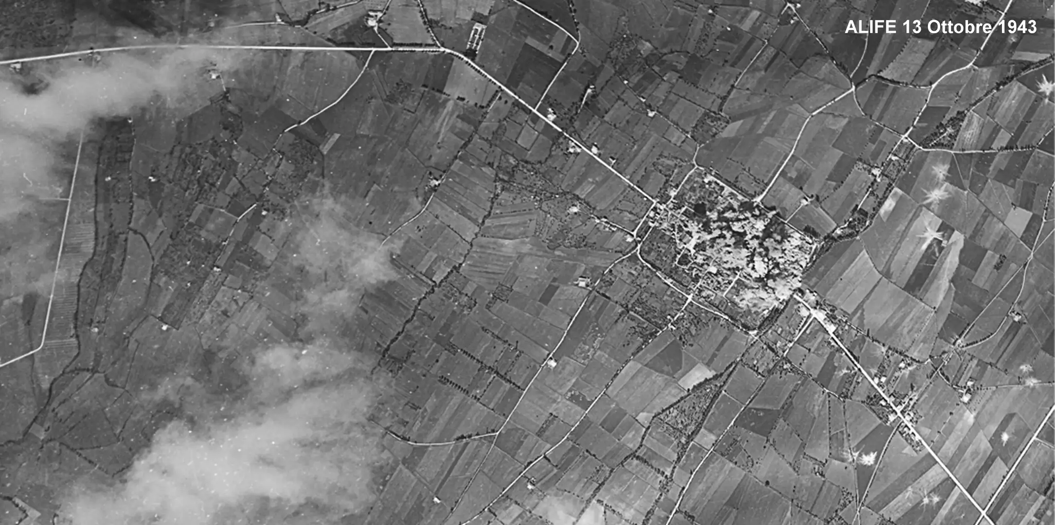
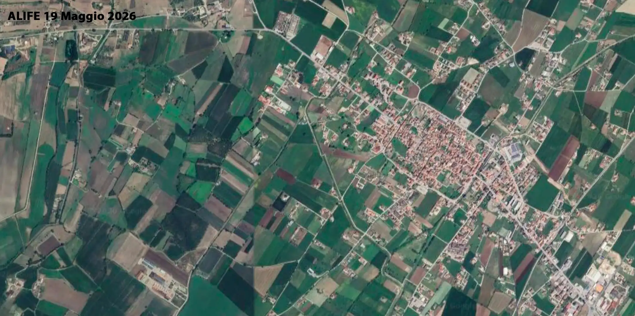
Le immagini che seguono mostrano Alife dall'alto in due momenti distanti ottant'anni: la prima è una fotografia aerea scattata il 13 ottobre 1943 — il giorno stesso del bombardamento o nelle ore immediatamente successive — probabilmente dagli stessi ricognitori della USAAF che documentavano l'esito dei raid. La seconda è una ripresa aerea contemporanea del 19 maggio 2026, che mostra la città ricostruita e ampliata nel corso del secondo dopoguerra.
Trascinando il cursore centrale è possibile confrontare le due immagini: si nota come il centro abitato si sia trasformato, con nuove edificazioni che hanno coperto aree un tempo aperte, mentre alcune strutture storiche — le mura romane, l'impianto della cattedrale — sono riconoscibili in entrambe le foto.
Sinistra: Alife 13 ottobre 1943 | Destra: Alife 19 maggio 2026. Trascina il cursore per confrontare. Fotografia aerea 1943 per gentile concessione del Dott. Giuseppe Angelone, Dottore di ricerca in Conservazione e Valorizzazione dei Beni Culturali.
La Memoria e il Ricordo
Il bombardamento del 13 ottobre 1943 rimane una delle pagine più dolorose della storia recente di Alife. Per decenni, la memoria di quell'evento è stata tenuta viva soprattutto dai testimoni diretti e dalle loro famiglie: chi c'era e riuscì a salvarsi, chi perse parenti e amici, chi tornò a trovare la propria casa ridotta a macerie.
Nel corso degli anni la comunità alifana ha cercato di non dimenticare, raccogliendo testimonianze, fotografie e documenti. Le immagini aeree del 1943 — probabilmente scattate dalla ricognizione alleata — rappresentano una prova visiva straordinaria di ciò che accadde: mostrano dall'alto la città colpita, i crateri, le strutture distrutte, il fumo ancora visibile in alcune riprese.
Oggi, ottant'anni dopo, quella storia merita di essere conosciuta anche dalle nuove generazioni: non come capitolo di un conflitto lontano, ma come parte integrante dell'identità di Alife e della Valle del Volturno.
Domande Frequenti
Ventitré bombardieri B-26 Marauder della USAAF sganciarono 88 bombe da 450 chilogrammi sul centro abitato di Alife nel giro di pochi minuti. L'impatto fu devastante: trentacinque civili persero la vita e gran parte del centro storico fu ridotto a macerie.
Alife era un nodo viario strategico nella Valle del Volturno, lungo le principali arterie di rifornimento delle truppe tedesche attestate sulla Linea Gustav. I tedeschi occupavano la città dopo l'armistizio dell'8 settembre 1943. Gli Alleati miravano a interrompere le comunicazioni e i rifornimenti nemici; la popolazione civile pagò un prezzo altissimo.
Il giornale Il Mattino scrisse "Alife eliminata", ma la città non fu rasa al suolo. Le mura romane — tra i simboli più antichi della città — resistettero in gran parte. La cattedrale e il castello subirono danni ma non furono distrutti. Il centro abitato, invece, subì danni gravissimi: gran parte degli edifici civili crollò e la popolazione fuggì nelle campagne e sui Monti del Matese.
Le fotografie aeree scattate il 13 ottobre 1943 provengono dagli archivi dei ricognitori USAAF che documentavano sistematicamente l'esito dei raid. In questa pagina puoi confrontarle con una ripresa aerea del 19 maggio 2026 usando il cursore interattivo: trascina il separatore per vedere come è cambiata Alife in ottant'anni.
In a few minutes of terror, on 13 October 1943, twenty-three American B-26 Marauder bombers turned Alife into a field of rubble. Eighty-eight bombs weighing 450 kilograms each struck the built-up area, killing thirty-five civilians and forcing thousands of people to flee. The newspaper Il Mattino would write: "Alife eliminated."
The Context: the Gustav Line and the Valley of Alife
The autumn of 1943 was among the most tragic in the history of inland Campania. After the Allied landings at Salerno on 8 September and the fall of the Fascist regime, the Germans withdrew northwards, establishing themselves along the Gustav Line, a defensive line that cut the Italian peninsula in two from the Adriatic to the Tyrrhenian, exploiting the Apennine chain.
The Volturno Valley — and with it the Valley of Alife — occupied a crucially strategic position: the roads and railways running up the valley were the main supply arteries for the German troops deployed at the front. Alife was an important road junction, and for precisely this reason it became a military target.
In the weeks preceding the attack, the city was already garrisoned by German troops. The civilian population was struggling to survive between roundups and food shortages, unaware of what was about to happen.
13 October 1943: The Attack
In the early hours of that Wednesday afternoon, the sky above Alife filled with the roar of engines. A formation of twenty-three B-26 Marauder bombers of the USAAF — United States Army Air Forces — approached the city from the south-west.
The B-26 Marauder was one of the medium bombers most widely used by the Allies in the Mediterranean theatre: twin-engine, capable of flying at over 400 km/h, with a bomb load of several tonnes. What they dropped on Alife was devastating: eighty-eight bombs weighing 450 kilograms fell on the built-up area within a few minutes.
"Alife eliminated."
— Il Mattino, post-war report on the bombing of 13 October 1943
The explosions came in rapid succession, raising clouds of dust and debris. Buildings collapsed like houses of cards. Streets and alleyways of the historic centre, still partly medieval, were buried beneath the rubble. Thirty-five civilians lost their lives; many others were wounded or trapped.
The Victims and the Flight
The thirty-five confirmed victims were mostly people who had not managed to take shelter in time: elderly men and women, children who were in their homes or out in the streets. The violence of the attack left no chance for those within range of the explosions.
In the days that followed, most of the population — already worn down by the presence of German troops and the lack of food — abandoned the city. Alife emptied. Families took refuge in the surrounding countryside, in caves on the Matese mountains, in neighbouring towns. Urban life came to a halt.
Only after the liberation of the area — which came in the following weeks as the Allies advanced along the Volturno Valley — did the refugees slowly begin to return, finding a city gravely diminished.
The Damage to the Historic Heritage
The bombing struck not only dwellings but also part of Alife's historic and architectural heritage. The city, which preserved important Roman, medieval and Renaissance remains, suffered significant damage to some historic buildings. The post-war reconstruction, though necessary, occurred in some cases at the expense of the original urban fabric, permanently altering the appearance of some neighbourhoods.
The Roman walls — one of the city's oldest symbols — largely withstood the devastation, as did several churches which, though damaged, were not razed to the ground. The medieval castle and the Cathedral of San Sisto also suffered the consequences of the attack, albeit to a lesser extent than the built-up centre.
Before and After: the Aerial Photographs
The images that follow show Alife from above at two moments eighty years apart: the first is an aerial photograph taken on 13 October 1943 — the very day of the bombing or in the immediately following hours — probably by the same USAAF reconnaissance aircraft that systematically documented the outcome of raids. The second is a contemporary aerial shot of 19 May 2026, showing the city rebuilt and expanded in the course of the post-war decades.
By dragging the central handle it is possible to compare the two images: one can see how the built-up area has been transformed, with new buildings covering areas that were once open, while some historic structures — the Roman walls, the layout of the cathedral — are recognisable in both photographs.
Left: Alife 13 October 1943 | Right: Alife 19 May 2026. Drag the handle to compare. 1943 aerial photograph courtesy of Dr. Giuseppe Angelone, PhD in Conservation and Enhancement of Cultural Heritage.
Memory and Remembrance
The bombing of 13 October 1943 remains one of the most painful chapters in Alife's recent history. For decades, the memory of that event was kept alive above all by direct witnesses and their families: those who were there and managed to survive, those who lost relatives and friends, those who returned to find their home reduced to rubble.
Over the years the Alife community sought not to forget, gathering testimonies, photographs and documents. The aerial images from 1943 — probably taken by Allied reconnaissance — represent an extraordinary visual proof of what happened: they show from above the stricken city, the craters, the destroyed structures, the smoke still visible in some shots.
Today, eighty years on, that history deserves to be known also by new generations: not as a chapter of a distant conflict, but as an integral part of the identity of Alife and the Volturno Valley.
Frequently Asked Questions
Twenty-three B-26 Marauder bombers of the USAAF dropped 88 bombs weighing 450 kilograms on the built-up area of Alife within a few minutes. The impact was devastating: thirty-five civilians lost their lives and a large part of the historic centre was reduced to rubble.
Alife was a strategic road junction in the Volturno Valley, along the main supply arteries for the German troops entrenched on the Gustav Line. The Germans occupied the city following the armistice of 8 September 1943. The Allies aimed to cut off enemy communications and supplies; the civilian population paid an extremely high price.
The newspaper Il Mattino wrote "Alife eliminated", but the city was not razed to the ground. The Roman walls — among the city's oldest symbols — largely withstood the devastation. The cathedral and the castle suffered damage but were not destroyed. The built-up centre, however, sustained severe damage: a large part of the civilian buildings collapsed and the population fled to the countryside and the Matese mountains.
The aerial photographs taken on 13 October 1943 come from the archives of USAAF reconnaissance aircraft that systematically documented the outcome of raids. On this page you can compare them with an aerial shot of 19 May 2026 using the interactive slider: drag the divider to see how Alife has changed over eighty years.